

With this FREE app, you’ll be taking the Paris Metro like a local
Are you intimidated by public transportation?
Don’t worry, I used to be, too. Prior to traveling to Europe, my only experience with public transportation was the Light Rail in Denver – a relatively limited surface train with just a few lines at the time, all heading into downtown Denver. Although everyone told me I had to take the Metro in Paris, I was super intimidated by the Paris Metro map. Combine that insane complexity with being in a foreign country and it made my heart race and my palms sweat. I decided I could probably get by without the Metro.
I quickly realized that Paris is huge and walking everywhere is unrealistic. While complaining about this over wine and cheese at my hostel, a fellow backpacker shared with me an awesome app that makes navigating around the city effortless. Even better, this app is completely free!
The best part is that it works in ALL major metropolitans throughout the world! Paris, London, Chicago, Boston, Lisbon, Copenhagen, Vienna, and more are all effortless thanks to this app. This app, along with a few others, are now staples on my phone and have made my travels both much easier and much more enjoyable.
Find out what the best Paris Metro app is below, along with the app’s awesome features!
Please note: this post may contain affiliate links. What that means is, if you click on a link and make a purchase, I may make a commission at no additional cost to you. For more information, please see my Affiliate Disclosure.
About the Paris Metro
The Paris Metro (short for Metropolitan) is a quick-moving, highly connected system of trains, lines, and stations. Composed of 14 lines, 303 stations, 62 transfer stations, and with lines totaling 128 miles, the Paris Metro can take you – very quickly and easily! – into just about any part of Paris. In fact, nowhere in Paris is more than 500 m from a Metro station! AND, even more mind-boggling is the fact that the Metro carries 1.5 BILLION passengers per year.

The Paris Metro is really like the main artery of Paris. During my first trip to Paris, I took the Metro literally everywhere. My second trip was different. During the entire length of my latest Parisian adventure, the entire country was in the midst of a long transportation strike. The strike lasted over a month – nearly unimaginable for the citizens of France.
What did that mean for me? No Metro! So I walked or Ubered everywhere – unfortunate because it’s often 15x more expensive and takes nearly twice as long.
So, moral of the story: you need to plan to take the Metro while visiting Paris. If that map I shared previously intimidates you, never fear: this app I’m recommending will make it stupid proof and super easy!
Citymapper – My FAVORITE Travel App
Citymapper is, hands down, one of the greatest travel apps I’ve ever used. I don’t often like paying for apps but this is one that I would be more than willing to pay for. I would even pay an annual subscription!
But it is FREE!
Crazy. So go pull up your phone and get it downloaded while you read why it’s so amazing.
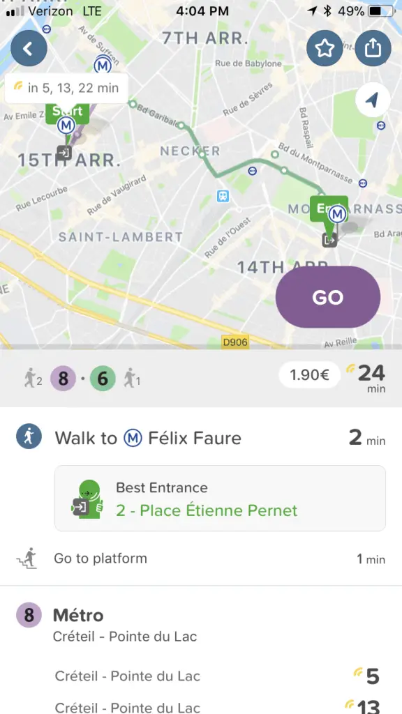
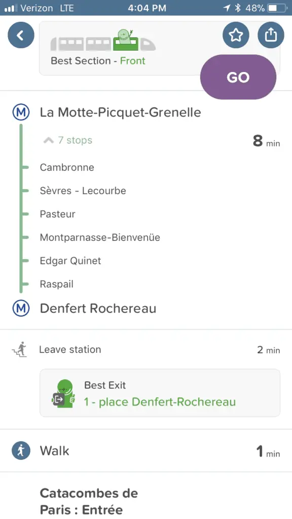
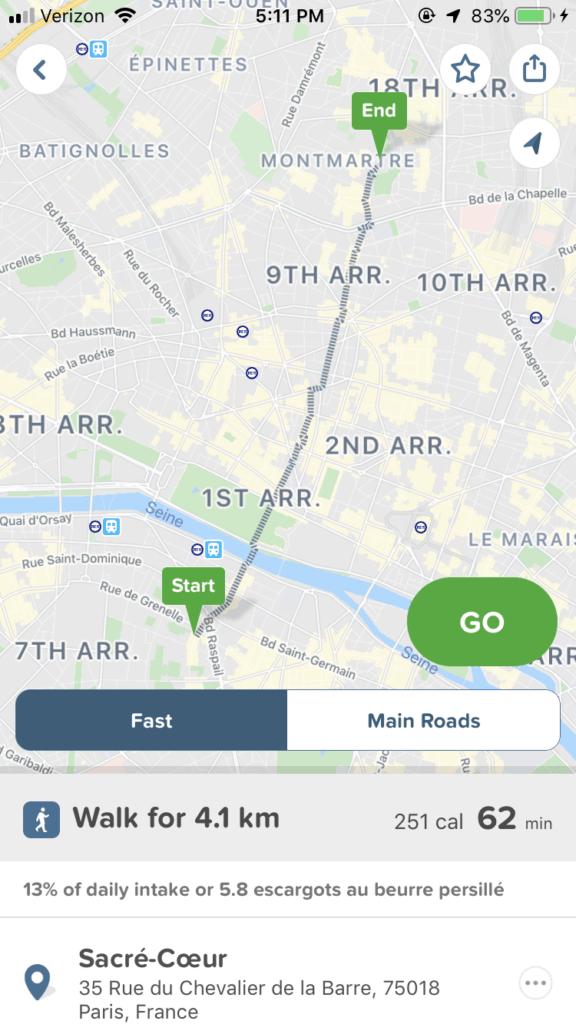
All the Metro details are quickly & easily provided
With Citymapper, there is no need to mess around with a complicated Metro map. All you do is plug in where you are and where you’re going and the app automatically tells you everything you need to know.
Literally, everything.
How long each Metro route will take. What platform to go to. What time the trains are coming. WHERE on the train to get on. What direction to head in. What stops are between your current location and your final destination. The cost of each option.
When I use Citymapper, I ride the Metro (and any other public transit elsewhere) so smoothly that I feel like a local.
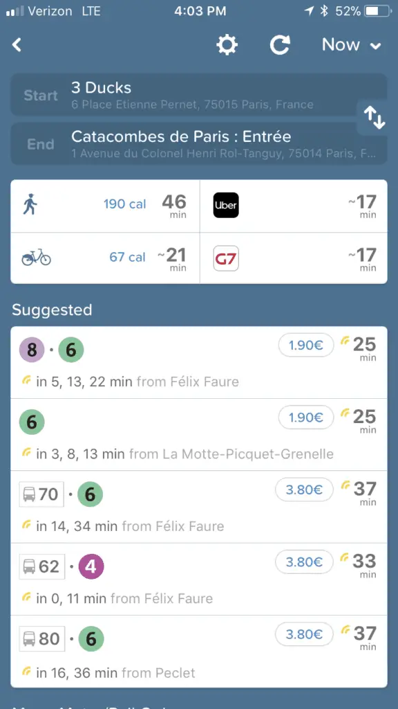
Alternative transportation routes, times, & prices are broken down
You don’t only have to take the Metro, however! Citymapper will provide a ton of other alternative options, including walking, Uber, on-demand bicycling, scooters, or any other public transportation option available in the city.
The time of each option along with the cost is presented, so you can easily pick something depending on what your needs are in the moment.
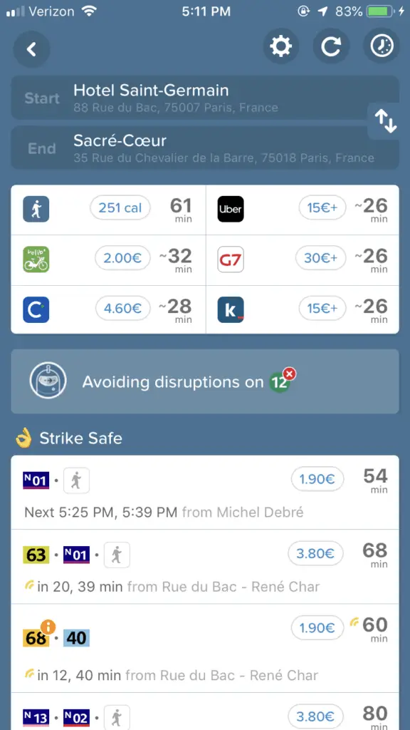
Data is up-to-date, in real-time
In the above image, you’ll see an entire section labeled “Strike Safe.”
This app KNOWS there is a transportation strike and provides accurate, relevant information so you’re not trying to take a Metro that isn’t available!
I, for one, think that’s pretty awesome. It makes me trust the app a lot more.
Even if you aren’t traveling during a strike, you can trust that Citymapper has up-to-date rail schedules. This is important when making plans!
Citymapper is still useful offline
You won’t get all the features of Citymapper if your device is offline, but Citymapper still works as a great offline map and Metro planning tool.
If you turn Airplane Mode off, all you need to do is turn off Cellular and Roaming to still have access to GPS but prevent any unwanted cellphone expenses.
You won’t be able to create route directions, but you will be able to pull up the map and see where you are. If you plan ahead, I would recommend that you route everything you want while connected to Wi-Fi and take screenshots for later access.
Remember to open up the entire route so you can see what trains are available, what platforms you need, and everything you need to know about intermediate stops so that you minimize the chance of getting lost!
Other Great Apps for International Travel
I wrote an entire post about this, so go check it out! Citymapper definitely works best when you’re online, but with how plentiful Wi-Fi is, you can easily stop in at a little cafe, purchase a cappuccino, and route anything you need. Screenshots are your friend.
My FAVORITE app for offline map use is called CityMaps2Go. Between Citymapper and CityMaps2Go, these are my two main go-to apps. CityMaps2Go excels as an offline map. You can create lists by city of places you want to visit. I have a color system so I can quickly identify each label as either an attraction I want to see, a restaurant I want to check out, my hotel, or anything in between.
It won’t navigate for you but you can use it to pretty easily find your own way. It excels for above-ground navigation.

Once you do something, you can mark it as “Done” (the grey stars) so that you can see what is left to check out!
Citymapper is the best app for the Paris Metro and will make it so easy to navigate the city effortlessly and like a local
Although Citymapper is useful throughout many cities in Europe, I used it many times a day in Paris. It is absolutely a staple in a city as big and well-connected as Paris. This app is amongst my must-haves and makes traveling and experiencing Paris so much easier.
Cheers and enjoy!